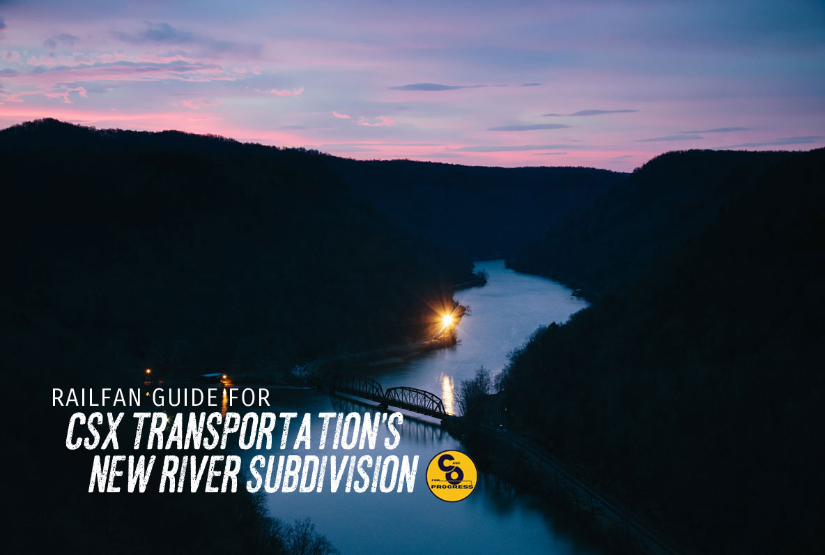
THE CHESAPEAKE & OHIO RAILWAY
Hinton — South Charleston, WV
A detailed, self-guided railfan tour
INTRODUCTION. This tour of what is today CSX Corporation’s New River Subdivision is part of Frograil’s self-guiding tour of the famous ex-Chesapeake and Ohio Railway mainline from Tidewater to the Mid-West. The overall tour introduction is here. Much of this segment of the tour is for aggressive, full-contact railfans. It is not a tour for someone with soft street shoes and a low-slung sedan. This is for combat railfans, and you’d better do some homework ahead of time.
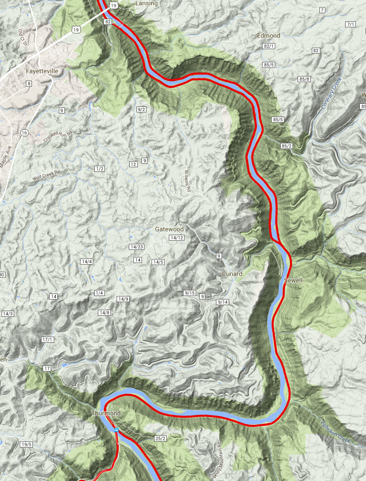
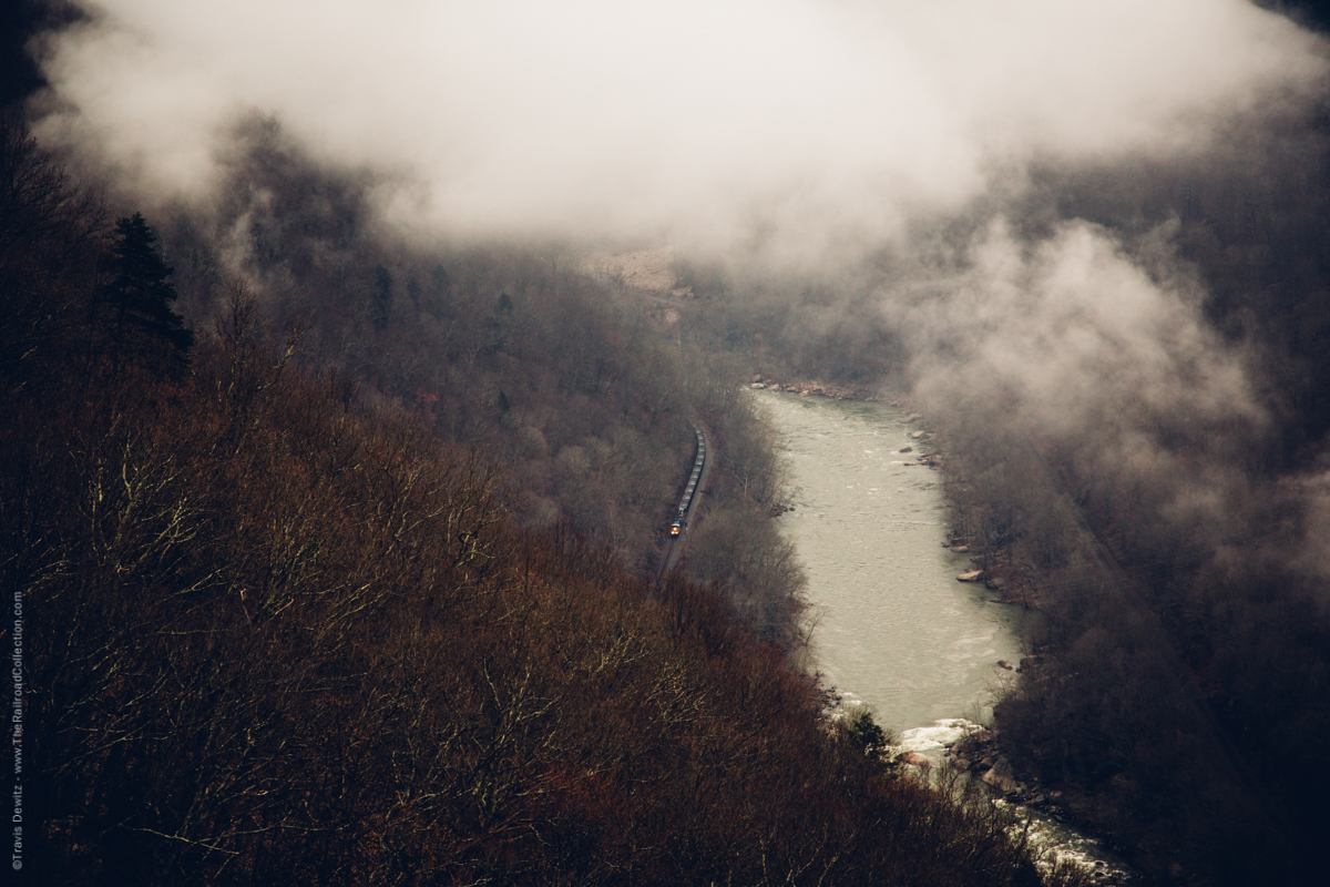
From Hinton all the way to Charleston, this segment of the C&O tour runs by some of the loveliest scenery in America. The New River first sees the C&O at Hinton, and then at Gauley Bridge the Gauley River joins the New to give birth to the Kanawha River. The portion of the tour between Hinton and Sandstone is under construction. At Sandstone, we enter the spectacular world of the New River Gorge National River. John Hopkins has provided excellent descriptive text for our tour of the Chesapeake and Ohio Railway thru West Virginia’s magnificent New River Gorge.
Between Hawks Nest State Park and Cabin Creek, the tour has a break. It picks up again at Cabin Creek and runs to the Amtrak Station in Charleston. Beyond Charleston, the tour picks up again at St Albans, and forms the beginning of the Charleston — Ashland segment.
This tour is also, however, part of what can be a delightful family vacation in one of the most beautiful areas in the East. John Hopkins has provided an overview of some recreational and cultural places to visit. These are written up in the Area Attractions part of this tour segment.
As with all tours in the railfan guide, you will be able to print out this text and hit the road, but before you do, we suggest you take a long, hard look at our tour guide “home” page — it’s got some good tips on it. That page is here.
CONTENTS AND NAVIGATION:
![]() ABOUT THIS TOUR
ABOUT THIS TOUR
![]() OTHER TOURS
OTHER TOURS
![]() CONTRIBUTORS
CONTRIBUTORS
![]() A REQUEST FOR HELP
A REQUEST FOR HELP
![]() SITE LISTING
SITE LISTING
![]() THE TOUR
THE TOUR
![]() SUPPLEMENTAL AND BACK-UP DATA
SUPPLEMENTAL AND BACK-UP DATA
![]() AREA ATTRACTIONS
AREA ATTRACTIONS
John Hopkins. The vast majority of the text covering the New River Gorge in this Tour, Supplemental and Back-up Data, and the Area Attractions is from John. However, unless otherwise indicated, any first person singular pronoun is a personal comment from the Webmaster. If you disagree with the comment, understand that it is my personal opinion, and not John’s.
John would like to thank the following folks:
“All the friendly CSX personnel that I’ve met at Quinnimont; the helpful and friendly employees of the National Park Service; and, Katy and Joe of the Thurmond Supply Company for their friendship and assistance. The biggest thanks, however, go to my wife of 30 years, Mechele for putting up with all my travels to scenic West Virginia for my second love: Photographing the coal trains in the mountains of Appalachia!”
Andy Wade. Collaboration and much of the text from Cabin Creek, thru Charleston, to Hurricane. This segment is complete between Cabin Creek and CSX’s South Charleston Yard. See the Charleston – Ashland segment for info west of South Charleston.
Train Gifs. All train gifs used within this tour are from the Ed Bindler’s train gifs site, which is here.
Peter Furnee, CSX logo
The Railroad Press. An earlier version of the New River Gorge portion of the tour was published in The Railroad Press. Copyright authority has been granted to Frograil, enabling us to bring you this updated tour.
Tony Hill, Webmaster — the guy who makes Frograil go. Any first person singular pronoun used in this text refers to Tony Hill, unless otherwise specifically mentioned.
A REQUEST FOR HELP: If you’d like to contribute to this, or any other tour, please contact me at frograil@yahoo.com, and let me know what you’d like to do. We’ll work together: You supply the data/info, and I’ll do the HTML stuff and upload it. You’ll get a chance to review the fruits of your efforts before the general public sees the finished product, so you can let me have your corrections, additions and changes.
Life Support. Yes, much of this tour is in a semi-wilderness, but there is plenty of life support from Hinton to Charleston. In the Gorge area, virtually of it is on the west side. Fast food, restaurants, grocery stores, gas stations, and the larger motel chains can all be found in the Beckley, Oak Hill, and Fayetteville areas. Campgrounds and cabins abound, as do combination gas/convenience stores. However, if you’re particular about film, your best bet is to bring it with you and stash the extra rolls in the cooler. Beyond the Gorge, US-60 to the north and WV-61 on the south bank offer plenty of basic life support. Beyond Cabin Creek, I-77 comes in from the south and you are then entering the Charleston metro area, so you won’t have any life support concerns.
Geography. For this tour, the region’s geography has an overwhelming impact on every railfanning consideration. The railroad hugs the banks of the rivers all the way thru. This is an area of spectacular scenery and challenges. You will see the adjectives “spectacular” and “fantastic” used frequently in this tour. They are not over-used. The un-relenting, steep vertical aspect of the mountains, the twisting and turning of the New River, and the smaller gorges coming down to the New River Gorge itself create a most difficult area within which to drive from point A to point B. There is no such thing as pacing a train here, unless you do so in a short area of the Gorge by jetboat. South/east of the Gorge and north/west of it, railfanning is drop dead easy.
Concerning the Gorge area, if you fail to do an adequate study of this area before you arrive for your tour, you will be cheating yourself out of much of the enjoyment that an efficient approach to the area can yield. John has done a great job of providing you with an excellent, detailed point-to-point tour, but you must supplement his effort with your own preparations.
The Railroad — General. The Chesapeake and Ohio Railroad, as the name implies, was built to link the mid-west (at Cincinnati) to the deepwater port at Newport News, Virginia. The economic justification was found in the coal in the middle portion of the railroad, which could be inexpensively shipped either to the east or west from central western Virginia and central West Virginia. The physical plant is in excellent condition, but there are only 3 passing sidings over a mile in length, so things can get interesting.
Railfanning considerations. John Hopkins has done a masterful job of presenting one of the most difficult railfanning areas of North America. He has been to the region several times, and updates his manuscript each time he visits. As a result, he makes the tour seem almost easy. It is not. It is extremely difficult: There are areas where no one lives; there are areas where even the best maps will let you down; and, there are a few fiercely independent people in the back country who do NOT welcome the casual railfan. At Frograil, we strongly recommend you conduct all tours with at least one male friend. We’d double the recommendation for this tour. Have a friend, and a darned good (as in tough and reliable) vehicle. Have your food and drink with you, and have your gas tank full. People living along the I-95 corridor and elsewhere in the “civilized” part of the country really don’t understand how difficult some of this area is.
Compass vs. railroad directions. The entire ex-C&O is timetabled east to west. Much of this railroad, however, is unimpressed with the timetable and far more influenced by mountains and rivers. We will try to be clear as to whether we’re talking about timetable or compass directions. Be advised, however, that the hills and rails can easily get you turned around. This is definitely one place you should have a compass. You don’t need an orienteering-quality device at all — a simple Boy Scout compass is more than adequate. You just have to be able to positively identify compass north to help you get your bearings.
Mapwork: Much of the tour is not easy if you have no detailed map for back country roads. I definitely recommend you get a DeLorme Atlas & Gazetteer, study it before your trip, and copy pertinent pages for your field work. You can usually get substantial discounts on DeLorme atlases thru the Frograil Railfan Store, which is here.
Abbreviations. Some phrases are used repeatedly in this tour, so I’ve developed some standard Frograil abbreviations:
AG. An at-grade crossing.
CR. County Road, as in CR-17-1 for example.
NAG. A not-at-grade crossing. Unless I mention otherwise, these are usually not worth the time and trouble to drive to.
NARL. Not a railfan location. This is because of any number of reasons, such as lousy photo ops, dangerous, no shoulder on a NAG bridge, etc. As a general rule of thumb, it is wise to avoid NARL’s.
Photographic Considerations: As I’ve done in several other tours, I’ve attempted to rate the photo fields for all 4 quadrants of the crossings on which I’ve personally done on-the-ground research. The following is an example of the format used: NE2, SE1, SW4, NW4, where you go clockwise around the quadrants from northeast to northwest, and numerical ratings, from 1 to 4, with a 1 being excellent, and a 4 being non-existent, are assigned. Note that I’m rating only photo field availability, not the photogenic qualities of the site. I’m a picture taker, not a photographer, and you guys who are good photographers will have to make your own determinations. When John remarks about photos throughout the Gorge, remember that he is discussing the photogenic aspects of the viewing, as he is a photographer, not a mere picture taker like me.
National Park Service status. Some things need to be said on behalf of the National Park Service and the park itself. First, within this tour, the word “Gorge” (capitalized) refers to the New River Gorge National River, and a place using the term “Gorge” is within the park. Any reference to a “gorge” (uncapitalized) is to a place outside the park.
Secondly, the National Park Service (NPS) had many additional missions heaped upon it in the 1990’s: Building expensive handicapped accessible structures, multi-culturalism and other such political correctness-inspired programs, vast new “National Monuments” created at midnight via a stroke of the pen, etc. However, no money has accompanied these added missions (note that the majority of these missions have come from the Executive Branch of the government, not the Congress, which controls funding), and the result is a general, very obvious weakening of the ability of the NPS to do the kind of job we’ve all taken for granted for so long.
Ranger-led tours are largely a thing of the past, because the rangers are directing traffic, carrying out programs which have absolutely nothing to do with our national parks, or, in many cases, those rangers simply do not exist — they’ve been victims of budgetary cuts.
Please take a moment to write your congressman and senators to let them know that the NPS should be caring for our national parks, not carrying out agendas which have nothing to do with those parks.
For those of you trying to find out information on hiking, biking, etc within the Gorge, I’d suggest you log on to www.gorp.com and search for the pertinent places.
Can’t get away for a few days of shooting trains without the family? Why not bring them along for a vacation in the area? This whole area is much more than just trains. Here are just a few of the many “non-train” things to do and see in the area.
Babcock State Park. This is the home of the Glade Creek Grist Mill, which is probably the state’s most photographed structure, and one you’ve probably seen on a calendar, post card or TV travel show. There are also cabins to rent and a restaurant. One of those cabins would be a pretty good base of operations for your vacation, and would be far more enjoyable than a motel room. A 5 1/2 mile (very much) unimproved road leads down to the ruins of Sewell, once home to some 600 souls and 96 beehive coke ovens. The narrow-gauge Manns Creek Railway, a C&O depot, and a mine-run terminal lasted here into the 1950’s, but little trace of these can be found today. Located off WV-41 in Clifftop. Tel: 1-800-CALL-WVA.
Bridge Day. Billed as the largest one-day event in West Virginia, and shown on newscasts throughout the world that night, the 3rd Saturday in October finds a Carnival-like atmosphere at the US-19 bridge over the New River Gorge just north of Fayetteville. On this day, the northbound side of the bridge is closed to traffic, and pedestrians are free to stroll across. Vendors set up their tents, trailers and various displays from the intersections on either side of the bridge up to, but not on, the bridge itself. From the bridge, some 400 or so intrepid (or maybe “insane” is a better adjective) souls jump, one every 15 seconds, from the bridge with a small sky-diving parachute, aiming for a small blue tarp on the west bank of the river 876′ below! Bridge Day is truly a sight to see.
Far below in the river, there are boats scooting around to pick up those divers who miss the bank and end up in the (really, really cold) New River. Also, from the superstructure beneath the bridge, rock climbers rappel down to the area of the #2 Main. On Bridge Day, one can get some great shots of eastbound loaded coal trains working upgrade, usually on the #2 Main. For other photo locations in the vicinity of the bridge, go to the Fayetteville locations in the Site Listing.
Bridge Day is a hoot — totally unlike anything else you’ve ever seen. You’ll have to do some walking and you’ll probably want to do some stair climbing, but if you don’t mind the crowds for a few hours, this is the place to be. For additional information, contact the Fayette County Chamber at (304) 465-5617.
Canyon Rim Visitors Center. In addition to the breathtaking views, you’ll find displays and a 12-minute slide show documenting the formation of the gorge, the construction of the bridge, and the history of the area, of which the mines and railroad played major roles. The Center also contains a small bookstore, rest rooms, and information about the area’s hiking and biking trails. (304) 465-0165.
Contentment. A pre-Civil War home, museum and restored one-room country school house can be found here. Open seasonally, it’s located between Ansted and Hawks Nest Lodge on US-60. For information, call (304) 465-0165.
Fishing. Known as one of the best warm-water fisheries in the east, the New River is home to small-mouth bass, catfish, redeye, and bluegill, among others. It’s one way to pass the time waiting for a train, but be sure you have a fishing license.
Grandview State Park. In addition to great scenic overlooks, you’ll find picnic areas, game courts, playgrounds, hiking and cross-country ski trails and an outdoor repertory theatre. The park is very popular in the spring, when large, plentiful rhododendron bloom. Phone (304) 763-7315.
Hawks Nest Lodge. A really nice, comfortable place to stay, reasonably priced, often booked well in advance, with picnic area, tennis court, outdoor pool, etc. There’s also a decent restaurant (the buffet is often well worth the price), a gift shop, an aerial tram that takes you down to the river, and jet boat rides up the river as far as the US-19 bridge. Timed right, some fantastic train shots can be had from either the rim or the jetboat! With only 31 rooms, reservations far in advance are strongly recommended. Phone 1-800-CALL-WVA.
Hawks Nest State Park. In addition to its great overlooks, you’ll also find a small gift shop, museum, picnic area, and restrooms. Hawks Nest Lodge is located within the State Park. For info, call 1-800-CALL-WVA.
Hiking and Mountain Biking. Numerous excellent trails dot the landscape, leading to scenic overlooks, along the New River, and to abandoned mines and towns. You’ll find maps detailing these trails at the NPS and State Park facilities. While a few locations on the Tour use trails as a way to get to a railfan location, there are many more trails in the area, and you’re only limited by your time and level of physical conditioning. If you think you’d like to try some trails, you can rent a mountain bike in the area west of the Gorge. Try Internet listings for Beckley, Oak Hill and Fayetteville.
Hunting. Hunting is permitted in much of the Gorge during the designated seasons. You should certainly check with the NPS and West Virginia authorities as to the dates of the various seasons in any specific area within which you plan to fan. If you’ve visited the Frograil Tour Guide, you know that I recommend packing an orange baseball hat. While you definitely should wear one during hunting season, the visibility it gives you can help if you get lost while hiking or biking, or if you slip and fall from a “perch”, and break an ankle. Such things really do happen (one more great reason for always fanning with a friend.)
New River Gorge by Rail. The Colis P. Huntington Chapter of the National Railway Historical Society runs a series of excursions thru the Gorge. This is a major train, not a dinky little pufferbelly excursion. Contact the Chapter via the Internet here, and book your reservations well in advance.
New River Park. Not to be confused with the New River Gorge National River, this is a park in Beckley. This is the home of the Beckley Exhibition Coal Mine (a definite “must see” — open from May until November, and again in December for a spectacular Christmas event!), the Youth Museum, and the Mountain Homestead Exhibit. From I-64/77, take exit 44 and follow the signs. It’s located on Harper Road. Phone (304) 256-1747.
Rock Climbing. This sport for the truly demented is permitted in much of the Gorge. There are outfitters in the region who provide both gear and lessons in climbing skills. [Webmaster’s Note: While there’s no doubt that some fantastic images could be taken while dangling several hundred feet from the top of a cliff, neither John nor I have tried it, nor do we expect to do so in the near future.]
Tamarack. Billed as the “Best of West Virginia”, this attraction offers “the art and soul of the mountains” in the form of various arts, crafts, books, knick-knacks, and other things made in or pertaining to West Virginia. Located in Beckley, at exit 45 off I-64/77. Good signs will get you right there. There is some very fine stuff in Tamarack, and it’s definitely worth a visit. If your spouse likes to shop, hold on to your wallet.
Whitewater Rafting. Numerous rafting companies are in the Fayetteville area, and offer exciting whitewater trips on the New River. John’s most memorable experience was with USA Raft in Fayetteville (Appalachian Drive off US-19. Their “express” trip offers a very refreshing mid-day break! Phone 1-800-USA-RAFT.) If you decide to raft, make sure you’ve got a waterproof camera. John has used disposable Fuji’s, as there’s always a chance for some trackside shots.
Wildlife. Copperhead and Timber Rattler snakes are the poisonous snakes in the area, and are certainly found along the right-of-way from about May thru October. Also, you won’t have any trouble finding poison ivy, brambles, ticks, chiggers, and some really voracious mosquitoes. Tick bites can be life-threatening, so always examine yourself for ticks after a visit to the woods.
Bears definitely do inhabit the area’s forests, so keep your food sealed and your eyes open! Elk are making a comeback in the area, as are mountain lions. Besides these somewhat exotic animals, wild turkey, deer, coyote, and various other critters are plentiful. John has spent over 100 days in the area since June of 1994, and has seen Timber Rattlers but not Copperheads, avoided the poison ivy, found a few ticks, lost a quart or two of his blood to the skeeters, spotted one (live) bear cub and one roadkill bear (not a good idea to hit a bear with the family rice-burner), seen a couple of foxes, a dozen or more ‘possums, numerous ground hogs, beaver, deer and turkey, and late one night he caught a quick glimpse of a mountain lion. He mentions the rumor that some of the area’s wild turkeys were swapped for some of North Carolina’s rattlesnakes, but that rumor is not confirmed. I can tell you, however, that turkeys have made a remarkable comeback in the area of the North Carolina piedmont surrounding Frog Pond, and that these were “seeded” back in the late 80’s and early 90’s. Maybe there’s some truth to that rumor, eh?
| WEBMASTER’S NOTE: I do not recommend or condone walking along the tracks, as this means trespassing and exposing yourself to danger. You will have to be creative, in some instances, to avoid trespassing while getting to the detailed locations included herein, but you will either have to be creative or not visit those sites. At no point in this tour guide, or in any other part of Frograil, is it recommended that you trespass or expose yourself to danger. If you are a fool and have a leg cut off (or worse), don’t come crying to me: You have been warned. Trains are big, powerful, and often surprisingly quiet. Don’t end up being a statistic. |
![]()
![]()
![]()
![]()
![]()
![]()
Site Listing
| Alphabetical Sequence | Sequential Order: East to West |
| Cabin Creek — West End | |
| Chelyan — 3rd Avenue | Begin New River Gorge Area |
| Chelyan — Slaughters Creek Road Area | Sandstone MP CA 366.3 |
| Chesapeake — 128th Street | Meadow Creek |
| Chesapeake — Big Eagle Rail | Quinnimont — Grandview State Park |
| Chesapeake — Nelson Hollow/120th Street | Quinnimont |
| Chesapeake — Winifrede Junction | Prince |
| Cotton Hill | Prince — Stretcher’s Neck Tunnel |
| Cunard | Thurmond — Stone Cliff |
| Fayette — East Side | Thurmond CA 390.8 |
| Fayette — West Side | Thurmond — Brooklyn – Southside Jct Trail |
| Fayetteville — Canyon Rim Visitors Center | Thurmond — Thurmond – Minden Trail |
| Fayetteville — Nuttall Cemetery Overlook | Minden |
| Fayetteville — Nuttall Station Overlook | Cunard |
| Hawks Nest State Park | Fayetteville — Nuttall Cemetery Overlook |
| Kanawha City — 50th Street | Fayetteville — Nuttall Station Overlook |
| Kanawha City — Chappell Road | Fayetteville — Canyon Rim Visitors Center |
| Kanawha City — Chesterfield Avenue | Fayette — East Side |
| Kanawha City — Nautilus | Fayette — West Side |
| Marmet — 85th Street | Cotton Hill CA 410.8 |
| Marmet — 98th Street | Hawks Nest State Park |
| Marmet — Ohio Avenue | McDougal |
| McDougal | |
| Meadow Creek | End New River Gorge — |
| Minden | Begin Cabin Creek – Charleston |
| Prince | Cabin Creek — West End CA 438.46 |
| Prince — Stretcher’s Neck Tunnel | Chelyan — 3rd Avenue |
| Quinnimont | Chelyan — Slaughters Creek Road Area |
| Quinnimont — Grandview State Park | Chesapeake — Winifrede Junction |
| Sandstone | Chesapeake — Big Eagle Rail |
| South Charleston — East End Yard | Chesapeake — 128th Street |
| South Charleston — I-64 Overview | Chesapeake — Nelson Hollow/120th Street |
| South Charleston — Montrose Drive | Marmet — 98th Street |
| South Charleston — Station Area | Marmet — Ohio Avenue |
| South Charleston — Yard Office | Marmet — 85th Street CA 445 |
| South Malden — Chesterfield Avenue | South Malden — Private Drive |
| South Malden — Private Drive | South Malden — Chesterfield Avenue |
| Thurmond | Kanawha City — Chesterfield Avenue |
| Thurmond — Brooklyn – Southside Jct Trail | Kanawha City — 50th Street |
| Thurmond — Stone Cliff | Kanawha City — Chappell Road CA 450.70 |
| Thurmond — Thurmond – Minden Trail | Kanawha City — Nautilus |
| South Charleston — Station Area | |
| South Charleston — Montrose Drive | |
| South Charleston — I-64 Overview | |
| South Charleston — East End Yard | |
| South Charleston — Yard Office |
The Tour
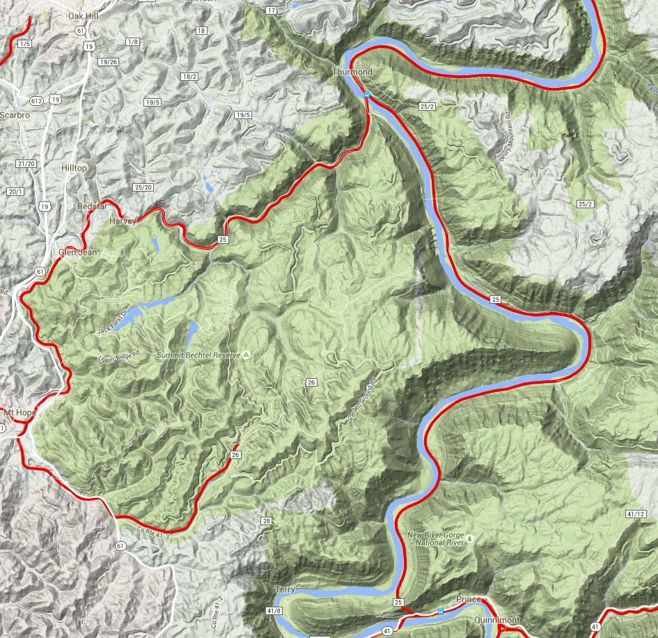
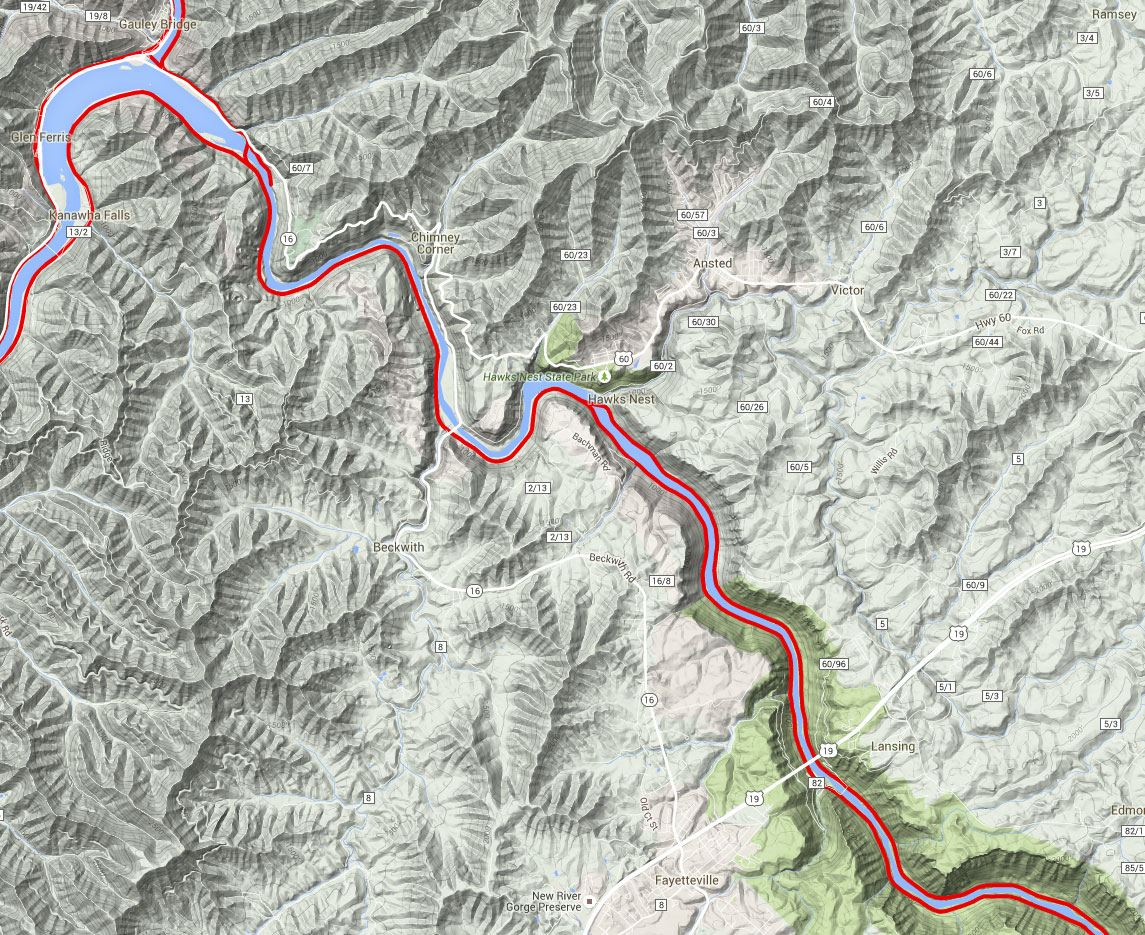
This segment will eventually extend from the logical start and end points of Hinton and Charleston, respectively. John Hopkins has provided the majority of this span for us, and it covers the CSX thru the New River Gorge. Please understand that John is a photographer, not a roster shot guy, and when he gives you a photo site, it will yield pictures from good to spectacular in quality, but you may have to climb up a cliff to get those pix. Nothing is easy. You’ll have to work for these shots, but when you show them at the local railfan group get-together, you’ll have a product probably unmatched by other photographers. So, we begin the tour in Sandstone, mile point CA366.3 on the New River Subdivision, C&O Division.
“Let’s roll“, to quote Todd Beamer, an American hero.
Sandstone. From Green Sulphur Springs west on I-64, take exit 139, and head south on WV-20. Just south of the intersection there is a crossing, and standing on or alongside the guardrail can yield a nice shot of an eastbound as it swings around the curve approaching the crossing. Another spot that works is just a bit further south where the road crosses a ravine and Laurel Creek on a deck bridge. From this bridge, despite being a bit “treed-in”, elevated, mid-day shots of lead units crossing an open deck bridge with the New River in the background can be had using normal to wide-angle lenses.
If you’re looking for a shot from the opposite perspective, the other side of this bridge can be reached by following a small dirt road (River Road) south from near the convenience store/gas station back by the grade crossing where we started. If the water level is low enough (be careful), you can often walk a few dozen yards out on the rocky river bottom to get a shot here.
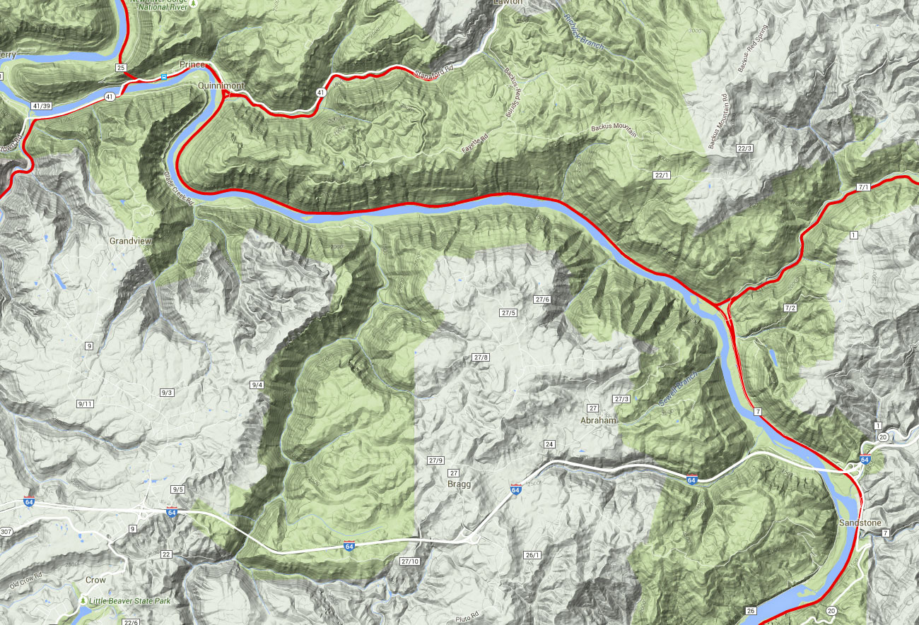
CSX New River Subdivision – Click to Enlarge
Meadow Creek. From Sandstone, we’ll now head north (railroad west). Go back towards I-64, and go northwest on County Road (CR) 7 for about 5 miles. There is a small interchange yard at Meadow Creek, where the Sewell Valley Subdivision joins the main line. The sub was formerly part of the Nicholas, Fayette and Greenbrier Railroad, once a joint C&O and New York Central property. This is an important coal gathering line, and goes up to Rainelle. This is a coal junction, and as befitting such a junction, there is a big abandoned coal processing plant here. Even today, the plant is most interesting. Also at this site is a put-in for river travelers who wish to go thru the New River Gorge. Your chances of seeing a few engines here are pretty slim, and you must be willing to walk a ways up the Sewell Valley Sub.
At the junction itself, if you care to do some grade-crossing shooting, props include a nice old hotel/restaurant and a signal bridge. Clear shots of the east end of the interchange can be had by following the tracks south (railroad east) for just a short distance. The other leg of the wye can be found by following the tracks west, but shooting here is very limited, and virtually all of this land is private property.
Remember that New River put-in for river travelers mentioned 2 paragraphs ago? Well, unless you’re floating north on the river, you’ll have to drive away from the rails, as the next few miles are completely inaccessible by road. We’re on our way to Quinnimont. While only about nine miles away by rail, it’s over three times that by road!
To go directly to Quinnimont, you can make a left turn onto the dirt road by the church after you cross back over the east leg of the wye, and follow this road (CR-7-1, Buerytown – Claypool Road), which will later become CR-20-8 at the Fayette County line. With a bit of luck, maybe you’ll catch the Sewell Valley Shifter working the 3.3% grade up to Meadow Bridge, but alas, most of this line is solidly treed in. So maybe you might want to put your camera down and enjoy the spectacle of diesel-electric horsepower fighting mother nature. When you get up the mountain, take a left on WV-20 and continue north. If you want an easier drive, from Meadow Creek go back south to I-64, go east, and at the second exit get on WV-20. Take WV-20 around and up the mountain on a much easier drive than the county roads.
In the village of Meadow Bridge, take a left onto CR-31/Main Street, and follow that to Danese, where you should take a left on WV-41. Follow WV-41 down to Quinnimont.
Grandview, WV
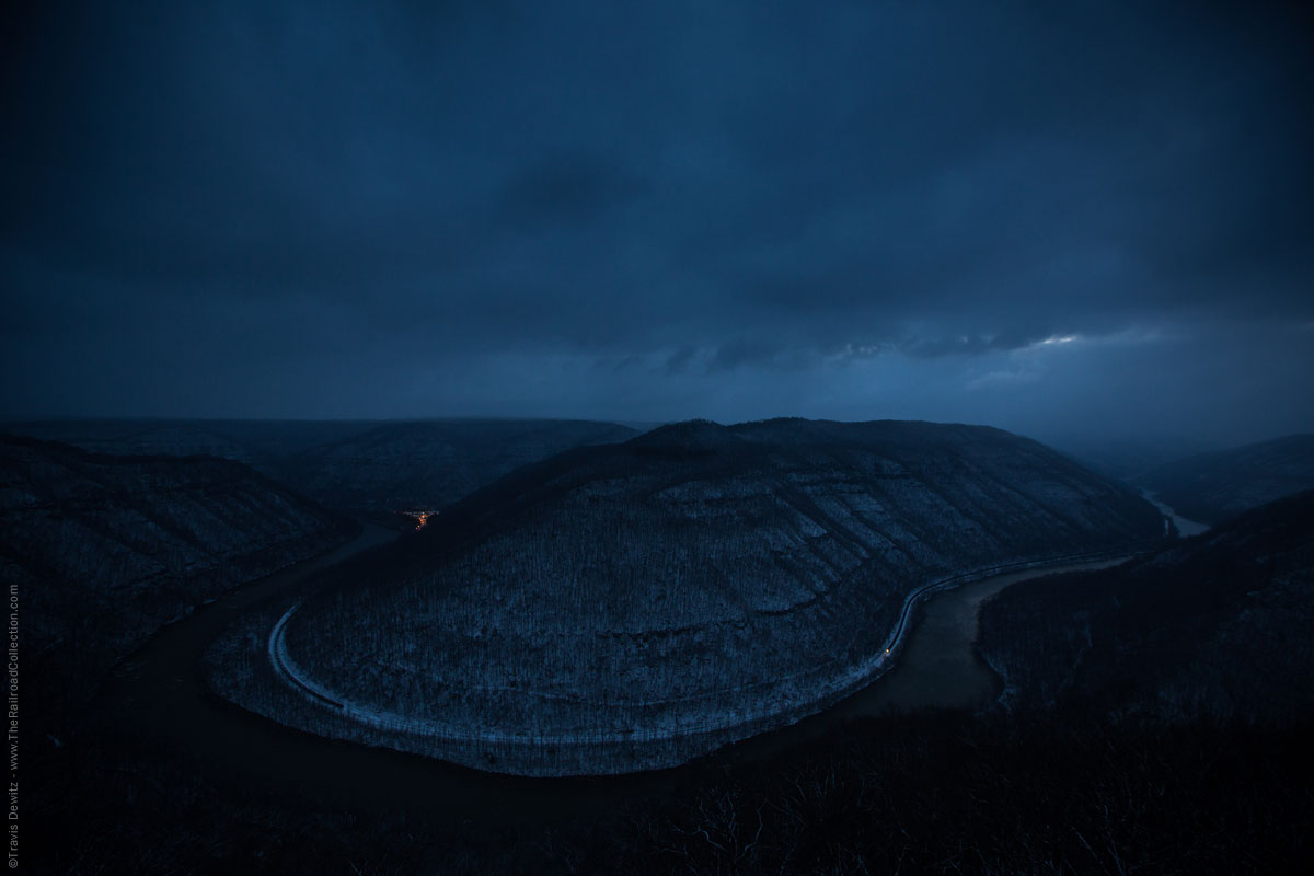
Quinnimont — Grandview State Park. On a clear day, here is a real visual and photographic treat: Why not shoot the yard at Quinnimont from the air? Can’t afford to rent an airplane or helicopter? No problem! Nature, with the help of West Virginia’s Park Service, has graciously provided the railroad photographer with some great elevated spots to shoot from. From Meadow Creek, go back to Sandstone and I-64. Travel west to exit 129, and go north, following the State Park signs north to the park. As is the case with other places encountered during this tour, it’s difficult to determine where the State Park ends and the NPS property begins, but that’s immaterial.
At over 1300′ above the river, it’s not too difficult to see where the park gets it’s name! An examination of the contour lines on a good map will give you vertigo. For those with a longer telephoto lens (300mm and up, if you’ve got one), here’s a place to get some real use out of it. Even without such a lens, however, you can get grand scenic shots with tiny trains dwarfed by overwhelming scenery. There is a choice of a few different overlooks, with each having something different to offer. The Main Overlook provides a nice view of Quinnimont Yard and the horseshoe bend at its east end. (Far up the river to your right, you may notice some bridge piers; these are about all that remain of the narrow-gauge Glade Creek and Raleigh Railroad, abandoned in 1917.)
The North Overlook will give you some great shots of Quinnimont Yard. While the park brochure claims that great views of Stretcher’s Neck Tunnel can be had from Turkey Spur Overlook, that may have been true some years ago, but the WV-41 overpass and some large trees have made good photos impossible. All that can really be seen from this overlook is part of the beginning of the Piney Creek Sub and about one and one-half of the three spans of the Piney Creek Sub’s truss bridge over the New River. This vantage point will also give you an idea of just how much the New River twists and turns, as you can see it folded back on itself as you look over Stretcher’s Neck. The road leading to Turkey Spur, however, will yield some views of the east end of Quinnimont Yard, along with most of the wye there, and a limited view of the tracks near Backus, east of the horseshoe bend mentioned earlier.
Quinnimont, WV
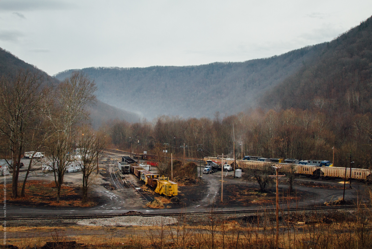
Quinnimont. The easiest and most practical way to reach Quinnimont Yard is to return to I-64 and take it west to exit 124, US-19, and head north towards East Beckley. Note that the DeLorme atlas shows a road, CR-41-1, that goes down to Terry Junction and the river. Today, that road no longer exists. At the northeast corner of the Beckley area, go northeast on WV-41, and follow it right down to Prince. We’ll come back to Prince shortly, but for now, continue on to the yard at Quinnimont. From Prince, continue on WV-41 for about a mile, and turn right onto Quinnimont Station Road. Use caution, as this road is short, narrow, steeply downhill, and curves sharply at the bottom. You’ll cross over what remains of the Laurel Creek Branch, now part of a wye, and some short yard and storage tracks.
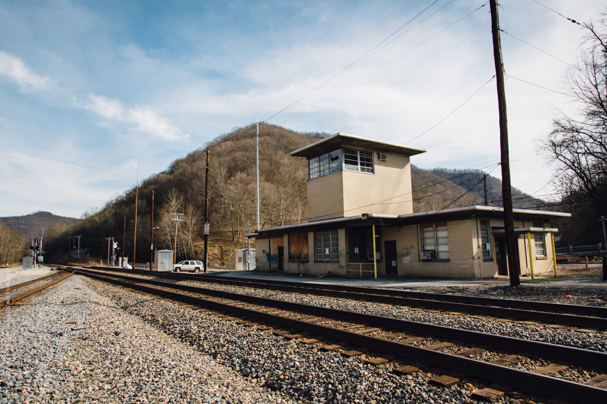
At this point, you may be asking yourself why in the world a fairly good-sized yard is necessary out in the middle of nowhere. As the following paragraphs will make clear, there is a lot of railroading activity throughout this region, and it’s all focused on Quinnimont. Steam Powered Video’s Appalachia and Piedmont Railroad Atlas is very helpful and informative for this area. The yard is the base for the shifters (CSX/C&O lingo for the local mine and industrial runs) that work up the Piney Creek Sub to Raleigh and then on to mines in the area, and also the Loup Creek (or G-P) Shifter, which runs to Thurmond and then up the Loup Creek Industrial Track to the Georgia-Pacific plant in Mt. Hope. Until recently, the yard office was a great place to find out what shifters were running in the area, but the clerks have now been moved to Hinton.
Amtrak Station – Prince, WV
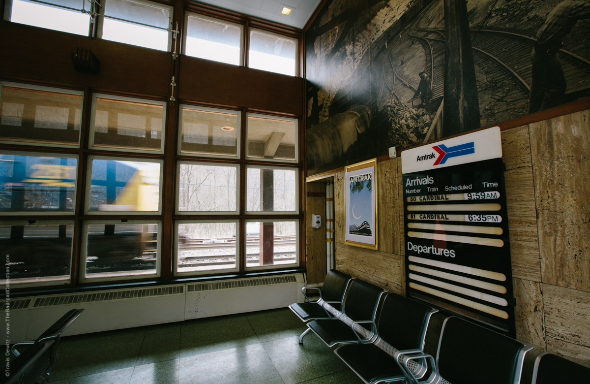
Prince. Backtrack to Prince. Here, the classic art-deco C&O station, which dates from 1946, makes a great photo prop, as do the signals both east and west of the station. If at all possible, take a good look at the station itself, as there are few such stations today, and certainly not many which see regular Amtrak service. The inside of the station is quite striking. The emblem on the floor of the waiting area is very attractive, and the mural on the west wall is a striking scene of bygone days. The depot is open at different times, but on days when the Cardinal is due, the agent is on duty from 10:30 to 18:30.
Just west of the station, at MP 379.7, the Piney Creek Subdivision branches off the main. This line crosses the New River on a three-span thru truss bridge parallel to WV-41 and heads up Piney Gorge to a small yard at Raleigh. From Raleigh, this line continues on to Baylor Mine, near Metalton, then on thru Glen Daniels, where the Maple Meadow Industrial Track and the Beckley Mine Industrial Track split off from the Piney Creek Sub. Just north of Raleigh Yard, the Raleigh Southwestern and Winding Gulf Sub (what a name!) branches off the Piney Creek Sub. It serves a loadout in Crab Orchard, and continues on to Pemberton. From Pemberton, CSX trains run on Norfolk-Southern trackage as far as Helen, where NS crews take the CSX trains to a mine over near Eastgulf to load and return. In late 2000, some of this trackage was out of service, but the steady revenue that CSX brings in caused NS to repair the tracks and put them back in service.
Most of these lines have many sharp curves and steep grades, and until about mid-1997 were served by multiple-unit sets of four-axle power often totaling ten thousand horsepower or more. Lately, CSX has been using six-axle power on these lines, with the new radial-trucked units preferred. As more and more AC4400CW power is delivered to CSX, the common power has become 2 such units, with a third unit as helper on heavier coal trains.
Stretchers Neck Tunnel – Prince, WV
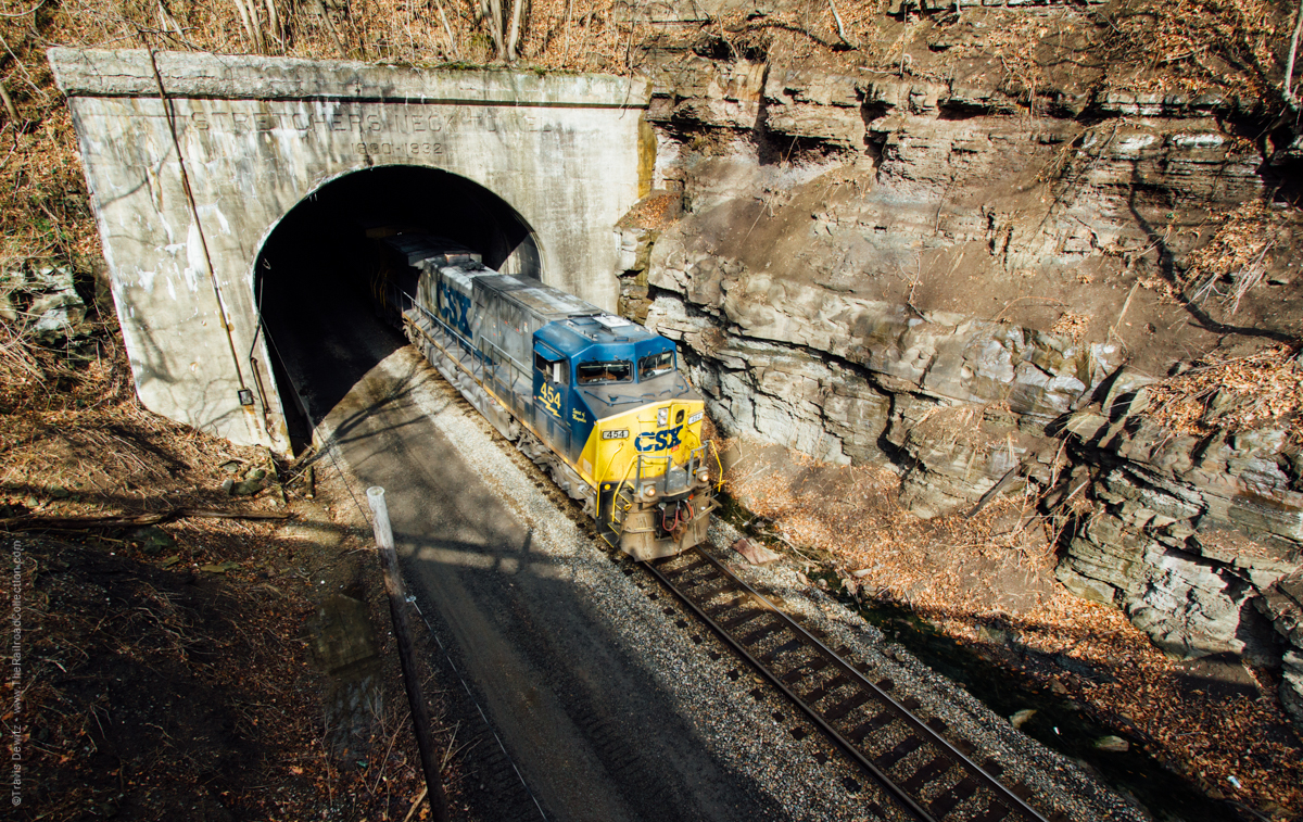
Prince — Stretchers Neck Tunnel. At the west end of Prince is the 1588′ Stretcher’s Neck Tunnel. This last remaining tunnel on the New River sports an eastbound grade just inside its west end of 0.44%. That, and the 2 1/2 miles of 0.4% grade just west of there form the ruling grade for the New River Sub east of Thurmond. Limited shots of eastbounds exiting the tunnel can be had from the WV-41 bridge using a wide-angle lens. From the other side of the bridge, a normal to medium telephoto lens is a good choice for westbounds through here. More shots can be had by taking a short walk down the railroad’s access road just west of the overpass, getting off railroad property, and then getting your shots.
Thurmond — Stone Cliff. Between Prince and Stone Cliff (about 1 1/4 mile south of Thurmond itself), CR-25/McKendree Road (which runs off WV-41 alongside Stretcher’s Neck Tunnel) provides a direct route. While it mostly follows the tracks, it’s nine miles of dirt and rock, with the easternmost 3-4 miles rough, rocky and ill-maintained. Webmaster’s comment: John has a jeep, and reports that the ride is uncomfortable in such a vehicle with tight suspension. I’ve driven it once in a full-sized, 6,000 pound van with soft suspension, and it was extremely uncomfortable. Much of the roadbed is large boulders with sharp drops. This nine-mile road will take you almost an hour — and maybe more. If you have a small, relatively low-slung sedan, you should be very, very careful. This is the worst public road I have ever driven in my life. There is very little traffic, there is not one commercial enterprise between Prince and Thurmond, and there is only one small village. Be prepared to take care of yourself if you have a mechanical problem. Once you start up this road, you cannot get off until you get to Thurmond — there are no roads connecting to it. This is a road from hell.
CSX New River Subdivision – Click to Enlarge
As an alternative — over twice as long, but easier and takes about the same amount of time — go back west on WV-41 towards Beckley, and take a right to go north on WV-61 when you exit Piney Gorge. As you head north on WV-61 towards Mt. Hope and Glen Jean, you’ll see CR-41-3 going off to your right. Keep your eyes open for what was an old grade crossing here. This is an abandoned spur which went up to a mine at Garden Ground. Rumors continue about this section of trackage being rebuilt to serve a reopened mine.
When you reach Mt. Hope (and limited life support), WV-61 will T and go north as WV-16/WV-61. Continue north, and at Glen Jean the routes will split, and you should stay to the right on WV-16. Follow the US National Park Service brown signs to the Visitor Center at Thurmond. The road to Thurmond is steeply downhill, very curvy, and unfortunately very scenic. It’s tough to keep your attention on the road (which is fairly busy, especially in the summer) and not the scenery. The scenery includes the forested mountains, a brawling mountain creek rushing down to the New River, and (ta-da!) the former C&O Loup Creek Subdivision fighting gravity in both directions. If there’s a shifter going up or down the sub, you’d better try to find a place to stop (very difficult to find such a thing, unfortunately), because you’re probably going to end up in the drink, otherwise. Take it easy and enjoy yourself, as this is truly a beautiful drive.
Loup Creek – Thurmond, WV
In 1995, this scenic branch was completely rebuilt and re-aligned to accommodate frequent shipments to and from the new Georgia-Pacific plant in Mt. Hope, just west of US-19. A siding with a loading facility for Austin Powder was added just east of US-19 in 1997. In the past few years, the grade crossings going down to Thurmond have been upgraded with flashing lights, so John doesn’t think that CSX is ready to pull the plug on the operation just yet! Indeed, lately there has been talk of an industrial park along the line in the area of Mt. Hope, a dinner train proposal has also been talked of, and if you add in the possible reopening of the mine near Garden Ground, the future for this line continues to look positive.
CSX now refers to the trackage as the Loup Creek Industrial Track; this steep line is usually serviced once a day by a shifter out of Quinnimont. One or two four-axle units used to be the rule for the Loup Creek Shifter, but like all the other lines in the New River area, a single, radial-trucked GE has since become the norm, with a caboose on the other end to facilitate the long back-up moves required. Frequently serviced at night, the weekend will sometimes see a daytime Loup Creek Shifter.
[Important update: In 2006/7, a minor miracle happened. A company owning coal reserves re-opened the loader at Pax, and RJ Corman completely re-built the line between Pax and Mt. Hope. Regular service has commenced, with (usually) 2 CSX AC’s on the head end, and 2 RJC SD’s on the rear. Going down the Loup Creek Valley to Thurmond with a heavy coal train must be a thrill, to say the least. As far as I know, the Loup Creek Shifter still does the CSX local work on the line as far as Mt. Hope.]
When you get to the bottom of the hill, you’ll be directly across the river from Thurmond. You’ll come to an intersection with a small triangle in the center: To your left is the Loup Creek Industrial Track and a siding, a parking area for a trail (more on that later) is straight ahead, and a dirt road goes off to your right. Take this latter road about 1 1/2 miles south, and it will take a 90º turn to the left and over the New River, and then a 90º turn to the right. The area of the bridge is Stone Cliff. The road continues south as McKendree Road, and while it does continue on to Prince (yes, it’s the same road that could have taken you directly here from Prince), you can park at Stone Cliff and shoot from the bridge. Be advised that while there is very little traffic here, the bridge is narrow and has no sidewalks, so remain alert.
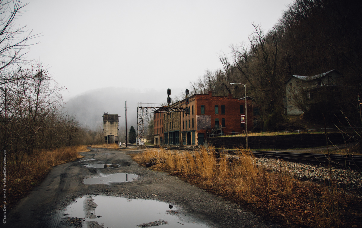
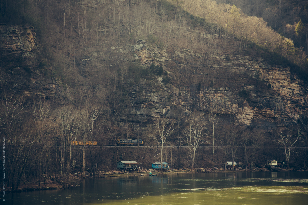
Thurmond, WV
Thurmond. Go back north to that intersection with the little triangle in it, and take a right, go over the river, and park in the NPS parking lot. The large 2-story building is the Thurmond depot. “Why in the world does this God-forsaken spot need such a major structure?” you’re probably asking yourself. There are no houses, no businesses, nothing but the railroad, the mountains and the New River.
Of all the places you’ll see in the New River Gorge, this is the one place that will draw you back time and time again. More than any other place in the area, this place says RAILROAD! There are lots of legends about this once rough and ready place: A non-stop poker game ran for some 14 years at the Dun Glen Hotel. The hotel was just across the river from “downtown” Thurmond, and it’s bar never closed from opening day until Prohibition. But here’s a fact, and one which will floor you as you look over the area: Before cars, trucks and roads managed to penetrate the gorge here, Thurmond was the top revenue producing town on the entire Chesapeake and Ohio Railway, considerably exceeding the revenue of such cities as Richmond, Virginia, and Cincinnati, Ohio.
Thurmond’s main street wasn’t a street at all — it was the C&O main line. While CSX has recently removed the 2 water tanks (dating from 1914 and 1927), the sanding tower, and a few small, ancient wooden buildings, several old structures remain. The water crane (also from 1927) has been removed, and is headed for Spruce, West Virginia, One can still find a number of good photo props to work into some of your shots. These include:
Thurmond Depot: Dating back to 1904, a complete restoration of this structure was finished in 1995. The current schedule has the depot open from 9-5 on summer weekends from late spring to early fall. This handicapped accessible facility contains numerous displays, a waiting room (remember, Thurmond is a flag-stop for Amtrak’s Cardinal), restrooms, and a small bookstore staffed by National Park Service (depending on budgetary constraints). When open, great shots can be had from the bay window in the telegrapher’s office on the second floor. Want to know if it’s open before you go? Phone (304) 465-8550.
Post Office: Originally the C&O Commissary when built in 1929, it was converted to a post office in 1963. In the spring of 1995, when the depot was opened, this was closed as an active post office. After that, it became the home of the Thurmond Supply Company until its closing in the fall of 1998, with Katy and Joe Miller selling candy, soft drinks, souvenirs, and renting out mountain bikes. Biking is a great way to see the area and explore some of the area’s abandoned rail lines. While the Supply Company is not now scheduled to re-open, if you come down here looking to buy or repair a mountain bike, give Joe a call at (304) 469-2380.
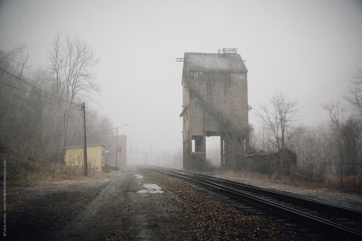
Coaling Tower – Thurmond, WV
Coaling Tower: Built by Fairbanks-Morse, this gem has a capacity of 500 tons, and dates from 1922. It still sports its original builder’s plate. Coal was unloaded in the center of this structure, with Loup Creek engines being coaled from the south side, and main line engines from the north. CSX had considered removing this structure in the fall of 1998 when they removed the water towers, but due to the cost and risks of damaging some of the nearby historic structures, it decided to shelve the idea, at least for the time being. Hopefully, this massive concrete structure will remain for future generations to photograph.
Other Props: These include a C&O cantilever signal bridge, a small weathered wood shed, and the three large trackside buildings left from the heyday of this once bustling burg. From railroad east to west, these buildings are the Mankin-Cox Building (1904), the Goodwin-Kincaid Building (from 1906, but only the exterior walls remain for much of this building), and the National Bank of Thurmond (built 1917, although the bank only moved here in 1923, after the elaborate stone front was added).
So, despite being the smallest incorporated municipality in the State of West Virginia (the 2000 census listed 7 as the population, and Lord knows where they live!), this quaint little burg is the kind of place that, despite its inglorious changes over the years, tends to draw you back again and again. Remember, also, that the Cardinal stops (whistle stop only) both ways during (scheduled) daylight hours, so check the latest schedules and try to get a carefully framed shot or two.
Thurmond — Brooklyn – Southside Junction Trail. Here’s another way to fan and enjoy the Gorge in the area north of Thurmond. Remember the intersection with the triangle in it? (Click here if you don’t). The small parking lot there, but before the river, is the parking lot for the Brooklyn – Southside Junction mountain biking trail. According to the DeLorme, this trail follows the river on the west bank all the way from Thurmond to Cunard, across the river from Sewell. There are actually three trails in this general vicinity, the Thurmond – Minden Trail (the next location we’ll visit), the BSJT, and the Cunard-Kaymoor mountain bike trail. It is unclear where the latter 2 begin and end but here’s the basic information: The trail is flat but rough, with rocks, gravel, and ties in some places. This roadbed is what remains of a track all the way from Thurmond to today’s start of “double” track at Bridge Junction/MJ Cabin. If you mountain bike that entire length, you’re a real man!
While it’s improbable that you’ll get perfect, tree-free shots across the river, it is certainly definite that you’ll get some very nice scenic/railroad shots that you’ll be quite happy with. The fishing is good, there aren’t a lot of people to bother you, and after all, you’re in the New River Gorge.
For more information on the trails in the area, contact GORP, and follow the search capabilities of the site. The National Park Service had started what was becoming a darned good web site containing info about the area and trails, but budget cuts have killed that effort.
Thurmond — Thurmond – Minden Trail. As mentioned in the previous paragraphs, this trail is also in the Thurmond area, but is west of (and much higher in elevation than) the river. Go back up the road towards Glen Jean, and a mile or south before Glen Jean, there is a parking lot at the trail head. The trail is the former Rend Sub, and went, as the name implies, to the town of Minden. At one time, there were 5 coal mines around Minden in star-like fashion. Today, there are none. You can hike or mountain bike the trail until you reach a huge rock blocking the trail. You can go around via a wooden stairway, but the trees and geography hamper much in the way of decent railroad shooting from the rock on.
At the rock, and a spot maybe a quarter of a mile before it (which you must have noticed along the way), you’ll find a couple of medium telephoto scenic views of the old buildings and the former post office.
Minden. For a really fabulous view of Thurmond, return to Glen Jean, take a right onto WV-61, and then another right when you get to US-19 and go north. As you come into Oak Hill (there’s lots of life support in this general area), take the exit for East Main Street. Take a quick left onto Minden Avenue/CR-17. The road is narrow and twists and turns, but it is paved. At one point, there’s a road on the right with a sign “ACE”; take that right. At the end of the road, you’ll find a gated picnic area, which seems to be generally open. In this area, you’ll see a picnic table far to the right. Just beyond the table is a view that on a clear day, will surely knock your socks off. This is the best overall view of Thurmond that you’ll likely ever see.
As is the case with many places in this fairly wild area, it’s a little unclear as to just what piece of property you’re on, and who owns the property can be even more confusing. According to DeLorme, the place is “Concho”, and is even labeled with a campsite logo. The “ACE” may refer to Ace Outfitters, but the property may be part of the NPS property. MapQuest shows 2 closely parallel roads going towards the overlook area, while deLorme shows only one. If you remember, we mentioned that there were 5 mines in the general area not all that long ago, and vestigial roads abound. Just follow John’s on-the-ground instructions.
![]()
![]()
![]()
![]()
![]()
![]()
Cunard. This is one of those spots that can often be a waste of time, but with a bit of luck, effort, and perseverance, it is possible to be handsomely rewarded. Read on, and decide for yourself whether you want to visit Cunard. Getting there is a little challenging, so be careful.
Return to East Main Street in Oak Hill and make a left (difficult as it may seem). Make a right at the second traffic light onto East Martin, then a quick left onto Gatewood Road/CR-14. Some maps refer to it as Salem-Gatewood Road. Whatever, follow it for about 5 1/2 miles to a right turn on WV-9. There’s an old, white, abandoned grocery store on the corner. Follow WV-9 right for about 1.9 miles, where you’ll see signs for Cunard Access. Once you enter NPS property, the road becomes steep, narrow and winding, so caution becomes the byword. Be aware in particular that Cunard is a major river put-in location, and numerous busses, vans and trucks use this road. It’s best to get in behind one, because they keep in touch with each other by radio.
CSX New River Subdivision – Click to Enlarge
Just before you reach the commercial rafting launch area, which is a sharp right, go straight, following the signs for the fishing area. This “road” is actually part of the former right-of-way of the South Side Subdivision, which ran from South Side Junction near Thurmond to Bridge Junction (just ahead) where it joined the South Main (now the #2 Main), a distance of about 7 1/2 miles. Parking here is on the left at the end of the roadway. From here, a short walk west along the old right-of-way will bring you to Bridge Junction and the #2 Main. To your right you’ll see the large single-span truss bridge that brings the #2 Main across the New River to Sewell, where the 2 mains meet.
As mentioned, this area can be a waste of time, but what a great place within which to waste time! If everything is running through on Main #1, than those great pix on the bridge will not happen, but on the other hand, you do have your fishing gear and license with you, don’t you? Trains that cross the river here will be limited by the 10 MPH speed limit for the bridge, and for about the first half of the day, they offer a nicely lit view from the area where the rafters are photographed. In season, the rafters easily become unknowing props in a great shot! It should also be mentioned that this bridge is old, and within the next few years will be due for extensive overhaul or replacement. It has been heard from more than one source that scrapping it, along with the #2 Main from here to MacDougall, is one option that is being seriously considered.
If you want to do something, just to say you’ve done it, you can actually get to Sewell, which is on the east bank. See the comments pertaining to Babcock State Park. Note that John refers to the path towards what was Sewell as “a boulder-strewn nightmare” in an e-mail to me about it. Not recommended as a railfan location.
Fayetteville — Nuttall Cemetery Overlook. Returning to Salem-Gatewood Road, take a right, following it to WV-16 in Fayetteville (and lots of life support). Another right will lead you to US-19, where you’ll make another right, and follow US-19 to the second right after you cross the fabulous New River Gorge Bridge, onto Edmond-Lansing Road. follow this about 2 1/2 miles to Beauty Mountain Road, where you’ll make a right onto this smooth dirt road. After a short distance, you’ll see a sign here for the Nuttall Cemetery. If the “spirits” (pun intended by John) move you, go to the cemetery, and walk respectfully all the way thru it to the power lines, and you’ll find a short trail that will take you to the rim of the Gorge for some nice views of both mains just west of Cunard.
Beauty Mountain – Nuttallburg, WV
Fayetteville — Nuttall Station Overlook. Another choice is to continue down Beauty Mountain Road about 2 miles, bearing right when you come to a short bit of pavement. You can either take the trail on the right (by the signs that say “Private Property — No Trespassing — Dusk to Dawn”) to the Gorge’s edge, or drive just a bit further to where the power lines meet the road. Right next to the poles is an easy to get to, great overlook of the mains in the area of Nuttall Station and South Nuttall, probably about 2 and 3/4’s of a mile from Fayette station where we’ll head soon.
Fayetteville — Canyon Rim Visitors Center. You cannot visit this area without seeing the visitors center up at US-19’s bridge over the Gorge. Head back to US-19, take a left, and then take your next left, following the signs to the Canyon Rim Visitors Center. Here, you’ll find various displays and three scenic overlooks. [Webmaster’s Note: The visitors center has some neat stuff in it. Once you see the bridge and the rails and river far below, you’ll want to leave with a neato T-shirt, sweat shirt, or at the very least, a nice ceramic coffee cup, which is what I opted for. Also, if you don’t get postcards for all the family members in your life who will hate you for being able to visit this super cool spot, you deserve to be miserable for a very long time.]
The upper overlook provides great views of the US-19 bridge (which is also known as the Rainbow Bridge, and is the longest single-arch bridge in the world), and just a few glimpses of the South Main on the opposite side of the Gorge. The lower overlook, requiring walking down a boardwalk with numerous steps, yields some views of the #2 Main and some glimpses of the #1 Main far below. The third overlook is around the back of the Visitors Center Building, and on a clear day, a medium-to-long telephoto lens will yield limited views of both mains.
New River Gorge Bridge – Fayette, WV
Fayette — East Side. But enough of the overviews — let’s get trackside, even though that might not be all that easy. Before we do so, let’s point out that Fayetteville is a town to the southwest of the US-19 New River Gorge Bridge, and Fayette is a former C&O station a little south of the bridge, and at track level in the Gorge. So, from the Visitor’s Center, turn right as you exit the parking lot, and at each of the next 2 intersections, make a sharp right (if your vehicle is long and has little ground clearance, and/or has a bit of overhang, you may very well have problems both here and at the grade crossing at the bottom of the Gorge due to grading and road widths) and follow this road as it twists and turns down to Main #1 at Fayette, MP CA404.3.
While most of the traffic here will be westbound (with the notable exception of Amtrak’s eastbound Cardinal), CSX has been running more and more eastbounds here, although slow eastbound coal drags are often run on the other side of the river. Some nice shots can be had here using the signals and (with a wide-angle lens) the bridge as props. One of the better spots can be found about 1 1/3 mile east of here, at a place called Whitcomb Boulder. Named for the chief engineer of the construction of the C&O main line thru here, no one knows when this huge chunk of Nuttall Sandstone fell from the rim of the Gorge. As it was far too large to remove, and as no room was left to go around it, workers were forced to cut and blast a portion of it away to allow room for one track. As engines and cars increased in size over the years, workers have returned to remove more of the rock to increase the clearances here, but a sizable amount of the rock still remains.
If you walk to the other side of the rock, you’ll see where someone once painted the name on it years ago. Signals here will help give an idea if anything will be along soon, but keep in mind that this is nowhere near a “wide-open” shooting area.
Fayette –West Side. Return back to the grade crossing, drive across the river on the newly restored bridge here to the #2 Main. Shooting is somewhat limited, but there’s one trackside spot you can try: Take a right into an old driveway on the sharp right-hand curve about 1/10 mile after you pass under the #2 Main (but if it’s been wet, this place can get very muddy and slippery). By parking here, and maybe doing a bit of walking, a decent shot or two can be had. If you have a wide-angle lens, you can also work the US-19 bridge into the shot. Leaving here, a right will take you back up to US-19. Along the way, you’ll find a hiking trail that leads to the old Kaymoor Mine site (Park Service had to dynamite the ruins not too long ago). The hike requires hoofing some 2 1/2 miles or so. Some decent shooting of the trains on both sides of the Gorge should be possible from the trail, but we cannot personally confirm that. On a clear day, you’ll find one or two sites that will allow a decent shot or two from along the roadway on the trip out of the Gorge. Please note that Fayette — West Side is known on railroad timetables as “South Fayette”.
Cotton Hill, WV
Cotton Hill. For the sake of convenience, we’re going to skip over a prime photo location (yeah, yeah, some may accuse John of saving the best for last!) and head straight for Cotton Hill, milepost 410.8. This is the most northern/western point on this tour. Note that about one mile north of the US-19 bridge, the NPS-administered New River Gorge National Scenic River park ends. After leaving the Gorge, we’ll make a right turn onto US-19, go one traffic light back to WV-16, and then turn right again. Some eight miles or so of somewhat twisting road will lead you down a small gorge to Cotton Hill, where the road crosses the two-track main (the two mains have rejoined and changed sides, but more of that later) and a somewhat anemic-looking New River (most of the water has been diverted to supply hydro-electric power to the area). Parking is limited here, but you’ll find a small area on the right as you approach the bridge, or you’ll have to park on the other side of the bridge. The Cotton Hill depot, visible from the bridge, makes a great photo prop. As it is now used by MOW crews, keep in mind that if you drive down the driveway to the park, you could find yourself with a problem, as the gate gets locked at the end of the day!
That said, great shots of either east- or west-bounds can be had from this new bridge (just finished in mid-1999), which replaces a very narrow, questionable structure, (not unlike the one found at Stone Cliff). While this new bridge has no walkways for pedestrians, it does provide one with a bit more room and a more stable platform than the bridge it replaced.
Hawk’s Nest State Park
Hawks Nest State Park. From Cotton Hill, we’ll backtrack somewhat, and head to the area of Hawks Nest State Park and Hawks Nest Lodge. This is one of the best overviews of this entire tour. Continue north on WV-16 to Chimney Corner, make a right onto US-60 (Midland Trail), and proceed to Hawks Nest Park. En route, you may find a few roadside spots that look like decent photo locations, but these are not railfan locations. The Park, however, offers a postcard view (if you don’t believe John, he suggests you look at all the postcards offered in the local souvenir shops) that can be had from a nicely placed overlook.
At some 585′ above the river, this overlook offers a fabulous view of the Hawks Nest Bridge, where, after some 10 miles of separate main lines, the #1 Main crosses the New River on a picturesque two-span truss to join the #2 Main at McDougal (MP CA408.9). You’ll also see the Hawks Nest Dam, built in the 1930’s, which diverts much of the water into a 3 1/2 mile long tunnel some 40′ in diameter (some claim the tunnel’s construction was probably the worst industrial accident in U. S. history, as over 600 workers died from asbestosis contracted during the construction effort) thru Gauley Mountain to a hydro-electric plant located over the mountain near Gauley Bridge.
CSX New River Subdivision – Click to Enlarge
Another great view can be had by walking a few dozen yards past the park overview to a left-hand curve in the road, where, from the guard rail, you’ll notice where a wire fence has been bent over as some people have crossed it to get closer to the edge of the cliff. Of course, we do not suggest you do such a thing, but it’s tempting, as great shots could be had from the edge.
From here, a short drive further east on US-60 will bring you to Hawks Nest Lodge. Park in the lot, and take the walkway from the right side of the lodge to the short trail leading down to a lookout called Lover’s Leap, and you’ll be rewarded with another fantastic view of the bridge and the Gorge, which are over 500′ below you. Here’s how you get down to the river level at McDougal:
Kanawha Falls, WV
McDougal. You have three choices: The easiest but most restrictive is to take the aerial tram. Since it runs on limited days and during even more limited hours, you’re at the mercy of the tram’s schedule, but the scenery is spectacular. A more energetic solution is to take the hiking trail down. Just remember that 500′ of vertical elevation gain on the way back up is a lot of fighting against the law of gravity. Add in the weight and bulk of photo gear, something to drink, etc. and you’re working real hard on the way back up. If you’re not in decent physical shape, do not attempt this hike.
To drive there, go further east on US-60 to the village of Ansted. As you round a curved fill with a road tunneling underneath, you’ll need to make a sharp left just after the police station/drugstore/discount liquor (now there’s a combination you don’t see every day!) and make another left to take you through the tunnel under US-60. The pavement soon ends, but the road is usually in decent shape. Be careful and pay attention now: Take a left after crossing the first small bridge, and a right just before the third (here’s where you’ll cross an old right-of-way, and at the top of a small hill you’ll notice a picturesque wooden trestle on your right, still intact. This was part of the Hawks Nest Sub, with grades over 4%. It served mines on Gauley Mountain. The line was abandoned in the 1960’s.), and continue following Mill Creek down the gorge to the bottom. From the parking area at the end of the road, you’ll quickly spot a few good spots to shoot from with just a bit of walking.
Handley, WV
The deck on the building near the marina is one spot you’ll quickly notice, and in bad weather it’s a great place to catch the action on the #1 Main while staying dry. Some of the best spots, however, can be found on the other side of the river, and these also provide you with some excellent views of trains crossing the bridge on the #1 main. South of the bridge on the west bank, there is an old green (fishing?) cabin alongside the river. Another great spot here is within a hundred yards or so of the bridge, where some kids have a rope swing set up for summertime fun. From here, a wide-angle lens will give you great shots of the bridge and include the lodge up on the cliff.
Here, perhaps more than almost anywhere else in the gorge, a scanner proves its worth in helping you get in position for trains heading your way, as the crews are required to call out signals as they are sighted.
![]()
![]()
![]()
![]()
![]()
![]()
![]()
![]()
[Webmaster’s Notes: At this point in the tour, there is a break of about 24 miles from the New River Gorge segment to Cabin Creek. Beyond Cabin Creek, I did on-the-ground research, and was greatly aided by input from Andy Wade of Hurricane. In fact, it was Andy’s input that got me to start the entire Cabin Creek – Hurricane section of the C&O tour. Note also that from Cabin Creek west, photo ratings at crossings are used, so you might want to check out photographic considerations.
For those who have just finished touring the New River Gorge, I think you’ll agree that from here west, railfanning is drop dead easy.]
Cabin Creek, WV
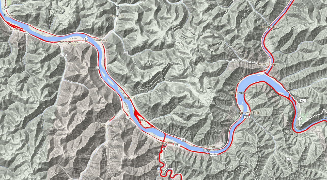
Cabin Creek — West End. We will pick up the CSX, ex-Chesapeake & Ohio tour in the village of Cabin Creek. Actually, the town may look small, but there have been millions (if not billions) of tons of coal that have come off the Cabin Creek branch, so this is a logical place to start our next C&O tour segment to the west. For those of you who are counting, this is mile point CA 438.46.
The area is a little complicated, but once you see what’s on the ground, it becomes much simplified. Cabin Creek Road is perhaps the west-most crossing in the wye area, and is a good place to start the tour to the west. As mountain railroading goes, it’s an excellent photo location: NE1, SE1, SW1, NW1. Enjoy these photo ratings, because they are the best we’ll see for a long, long way. As you stand on the crossing looking east, you’ll see the northeast leg of the wye coming in from your right, and the main line to Hinton going straight.
This is an excellent photo and train watching location.
Chelyan — 3rd Avenue. From the west end of the Cabin Creek wye, we will be either on or very close to WV-61 all the way into Charleston. In this area it’s known as 3rd Avenue. As you enter Chelyan from Cabin Creek, there is excellent viewing all the way thru town and up to the various feeder roads at the Admiral TJ Lopez Bridge over the Kanawha. I’d rate the photo locations as N1, S4, as I couldn’t see any place to take pix from the south of the tracks.
Chelyan — Slaughters Creek Road Area. In the afore-mentioned Lopez bridge area is Slaughters Creek Road. Like the rest of the Chelyan, I’d rate the area west of the road as N1, S4. Just past Slaughters Creek Road is MP CA 439. There is plenty of room between 3rd Avenue and the tracks for very good pix.
Dickinson, WV
Chesapeake — Winifrede Junction. As you near the town of Chesapeake, Fields Creek Road will go off to your left. That road, Fields Creek itself, and Big Eagle Rail (ex-Winifrede Railroad) play a classic coal mine branch line dance up the valley to the south. Fields Creek Road can get you close to the crossing of the Winifrede and the CSX main line. The crossing is not at grade — Big Eagle goes under the CSX main. Photos are OK, but there is limited depth of field.
To the right of WV-61, just before Fields Creek Road, look to the right for the engines employed by the Big Eagle Rail. You’ll have to get permission to enter the property and photograph them, as there is little photo access from public property (see next entry).
CSX New River Subdivision – Click to Enlarge
Chesapeake — Big Eagle Rail. If you have time, it would be worthwhile to take a drive up the Fields Creek valley to check out this “up-the-holler” classic West Virginia short line coal hauler. As of March 2007, they run 2 loaded and 2 empty coal trains most days. The line is only about 6.5 miles long, but used to be quite a bit longer. If you want to really explore the Big Eagle and its predecessor’s abandoned right-of-way, a copy of the USGS 7.5′ quad map “Belle” would be most helpful.
Trains can be shot at several locations up Winifrede Holler. The old engine house is about halfway up to the mine.
While this is a private coal company railroad, they can be railfan friendly provided ‘courteous’ railfans check in at the office, and get permission as to where they can and can not shoot. Trespass without checking in, however, and they will not be friendly.
Frograil would like to thank Ron Stafford and Matt Crouch for the information concerning Big Eagle Rail and the Winifrede Junction area.
Chesapeake — 128th Street. Continue west (compass north) on WV-61. When you cross Field Creek you’ll be in the town of Chesapeake. From here to Charleston, two things happen. First, 3rd Avenue/WV-61 becomes MacCorkle Avenue/WV-61. Second, the cross streets are consecutively numbered, beginning with 138th Street. The importance of the latter should be emphasized. No matter were you are — Chesapeake, Marmet, South Malden, etc — the street number logically and consistently decreases as you get closer to Charleston. The numbered streets continue to 31st Street, which is a little south of the University of Charleston. The railfan visiting for the first time will almost always know exactly where he is, just by checking one street sign.
Continue on MacCorkle all the way to 126th Street and take a left. After one short block, take another left onto Ohio Avenue. You could have gotten onto Ohio way back off of 138th, but part of it is one way, so this will allow you to drive the entire length of Ohio without running into the Do Not Enter signs. There is limited viewing along Ohio, but the railroad is fairly far overhead. You’ll see a small road going up the railroad embankment on the diagonal. This is actually an extension of 128th Street. Park along Ohio and walk up to the tracks — don’t try to drive up. The crossing is MP CA 441.92.
Photo ops are not particularly good, at NE4, SE2, SW2, NW3. However, this spot is at grade, and you can get shots here if you don’t have time to get to a better photo location. Also, there are signals that can help with your planning.
Chesapeake — Nelson Hollow/120th Street. Get back out to MacCorkle/WV-61, take a left, and continue to 120th Street. Take a left and drive to the crossing. In Chesapeake, this is 120th Street, but on the southwest side of the tracks, it becomes Nelson Hollow Road. This is that very good photo location you may have wished for just over a half mile south at 128th Street.
CSX New River Subdivision – Click to Enlarge
The crossing is MP CA 442.53, and it’s photo ratings are: NE2, SE1, SW2, NW1. Note that you’re on an “x” here and not a “+”, so take the designation of the quadrants with a grain of salt. Because you are on an x, you can get photos from at least one quad virtually all day, no matter where the sun is.
Marmet — 98th Street. Continue northwest on MacCorkle. When you approach Marmet, WV-94 will go to the southwest on a NAG/NARL, so ignore it. The street will make a 90º turn to head southwest, and then another 90º turn to head back to the northwest. Two blocks after the second bender, take a left onto 98th Street and drive to the crossing and park. This is primarily a morning shot, as the tracks have become a little more northerly: NE1, SE4, SW2, NW1.
The crossing itself is at MP CA 444.26.
Marmet — Ohio Avenue. Between the crossing at 98th Street and the next location up at 85th, Ohio Avenue hugs the tracks to the west. This is the first time on this tour (from Cabin Creek, that is) where we have wide open access from the west. There are plenty of potential spots, even in the summer, but as always, winter railfanning opens up many more spots for you.
Marmet — 85th Street. This is not a particularly good photo location, but it’s an excellent place to just sit and relax and watch CSX’s big dogs move the tonnage. Ohio Avenue will end at 85th Street. The crossing itself is NE3, SE4, SW1, NW3; there is a vestigial pole line on the east side of the tracks that hurts photos from that side. The MP CA 445 marker is just north of the crossing.
Dupont City, WV
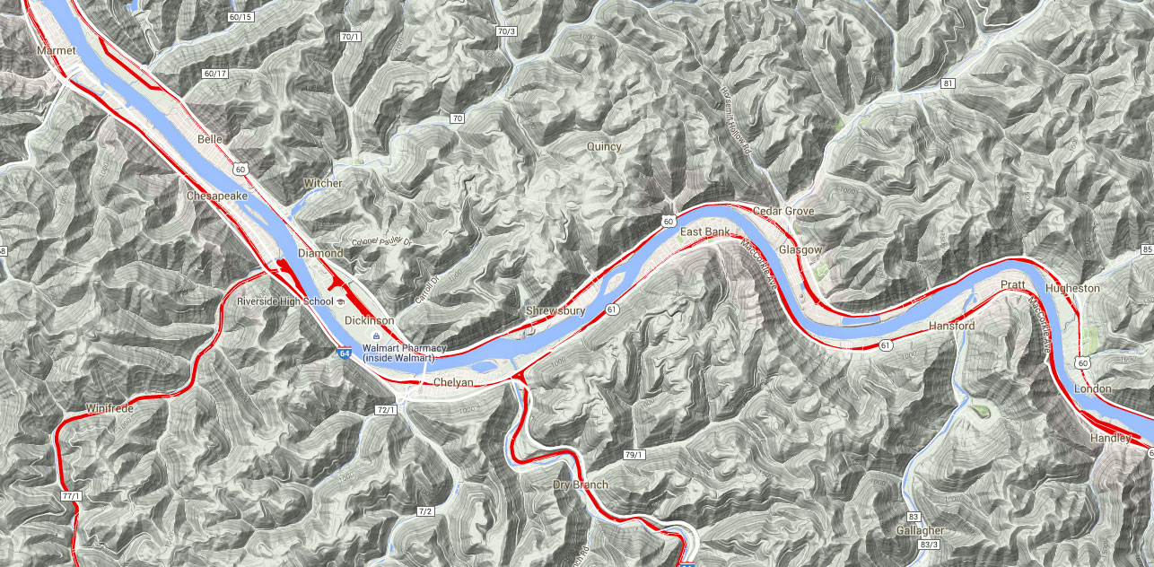
South Malden — Private Drive. As you leave Marmet, the interstate will go over the tracks and McCorkle. Just north of this place is a defect detector (MP CA 445.5) that you’ve probably heard all the way from Cabin Creek. Pass up CR-23, as it’s NAG/NARL. Beyond the DD, everything gets very tight, with the interstate, MacCorkle and the railroad all scrunched together like a 3-wide at Bristol Motor Speedway. Just before the interstate moves a little to the east, there is a steep private driveway going up and over the tracks on the familiar diagonal. There are signals (2 triple head masts), which will help you gather info, but there is a pole line on the west that is certainly no help. Still, shots to the southeast I think can be quite good, especially since most westbounds use the track closest to MacCorkle.
If you need to get trackside in a hurry, this place is fine. Park at the road and walk up to the crossing, get your pix and leave. This is a private driveway, so it is not a train watching location. MP CA 447.37.
South Malden — Chesterfield Avenue. North of the private driveway you’ll enter South Malden proper. MacCorkle hugs the tracks but is treed in and photos are schlecht to impossible. Look for Chesterfield Avenue peeling off to the left and take it. The crossing is quite good from the west: NE2, SE3, SW1, NW1. This is a good photo location, but is rather noisy from the interstate. MP CA 448.31.
Kanawha City — Chesterfield Avenue. There is no specific, single location for this area. Drive a little north of the Chesterfield Avenue crossing via Chesterfield, and the viewing is wide open until just a little south of 58th Street. In fact, this is one of the few places between Cabin Creek and Charleston where you can get decent viewing from both east and west of the tracks in a place other than a crossing: E2/3, W1. Note that in summer, you should have heavy boots and long pants and a long sleeved shirt if you want to tramp east of the tracks. This is a 3 rating because of lineside vegetation growth in the summer.
In the winter, you’ll still want boots and long pants, but you don’t have to worry about ticks, chiggers, and poison ivy. Plus, the viewing rates a 2 simply because the summer’s growth has mostly withered away. If you brought a weed whacker with you, you’d get better viewing any time during the year.
Kanawha City — 50th Street. Continue north on Chesterfield Avenue, and it will bend considerably from northeast to northwest, rather dramatically altering lighting/photo considerations. However, a little before 58th Street, the railroad becomes treed in, and to make matters even worse, there’s an old pole line on the west side. beyond 55th Street, the street and railroad are at almost a perfect 45º southeast- southwest angle (technically a 315º angle). At 50th Street there’s a crossing, and it’s NE3, SE3, SW1, NW3. Remember folks, this is now an “x”, not a “+”.
The mile point at 50th is 449.78.
Kanawha City — Chappell Road/39th Street. Chappell is a better place to watch trains than to photograph them. Chesterfield Avenue will take you to Chappell/38th, and there is parking to the right before you get to Chappell. Chappell is probably the busiest crossing street we’ve seen since Cabin Creek so be careful. NE3, SE4, SW1, NW3, and the mile point is CA 450.70.
Kanawha City — Nautilus. Head further north on Chesterfield Avenue, and you’ll shortly be going almost due west. Pass up South Park Road, as it’s NAG/NARL — a nasty old underpass. However, just beyond Park is a large parking lot on your right. As of the summer of 2007, the building at the southwest corner of the lot was a Nautilus Fitness Center. Relative to the probable demand for parking, this is a huge parking lot! Park in the far northeast corner. If I were you, I’d get permission from Nautilus first. Think about it: This is a fitness center and an attractive female comes out and sees a guy with a camera across the way in the lot. Hmmmm…put 2 and 2 together and come up with 15. The guy with the camera is obviously a voyeur — or worse. Call the cops!
Photo ratings are N4, S1/2, with the view from the south depending on the location of the photographer relative to poles, and also which track the train is on.
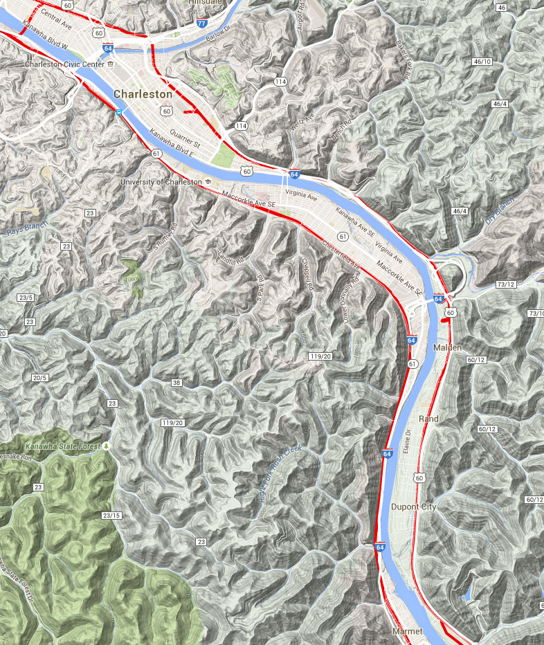
South Charleston — Station Area. We now enter an area where the surface topography is quite different than that we’ve seen from Cabin Creek up to this point. Just look at street maps for Kanawha City south to Cabin Creek, and then look west of about Park Road or 31st Street. Beyond 31st, all the roads south of MacCorkle/WV-61 suddenly become “round” instead of straight. Harder to say than see on a map. We’ve entered a basin-type valley, within which flourish Charleston and South Charleston. We’ll find very few places to railfan for awhile. In fact, as a generalization, the Charleston city area is quite difficult to satisfactorily railfan. So, here we go to the station.
You should also be advised that about the time I left the Nautilus parking lot, my allocated time had run out, and I had to get on the highway to head south to Frog Pond. Keep in mind, therefore, that I did not do my normal due diligence between Nautilus and the Amtrak station. You’ll be 85% informed, but there are a few little places I’d like to go back to. Andy Wade will pick up the narrative west of the station, and his material is much more complete than mine east of the station.
CSX New River Subdivision – Click to Enlarge
You can continue west on Chesterfield Avenue for quite some distance, but it suddenly peters out, and the viewing is poor all along the way. Therefore, take a right onto 31st Street, cross the tracks on a NAG/NARL, and take a left onto MacCorkle/WV-61. Just north of the University of Charleston, pass up 19th Street/Ruffner Road, as it is NAG/NARL, and then pass up Goddard Road, which is likewise NAG/NARL. Note that Callie Road comes off from Goddard to the southwest of the crossing, and seems to be close to the tracks, by I did not personally observe it.
North of Goddard, there is what appears to be a crossing at 12th Street, but it was not observed. Finally, the last not observed crossing was at Dickinson Street, but that is almost surely NAG/NARL. To get to the station follow the Amtrak signs. It will have to wait for a proper description of the station area and the station itself before this is a decent railfan location description, but realize that this is an active Amtrak station in a large city in West Virginia, so be careful in the area.
South Charleston — Montrose Drive. Less than half a mile (timetable) north of the station, US-119 goes south. At least, that’s what all the maps say, and they’re correct, but you’ll never hear it called US-119 or even Route 119; it’s Corridor G. If you need a break from railfanning, continue several miles south down Corridor G, and a number of huge shopping areas will appear. This whole area is called Southridge. This is the best place in the area to get a decent meal, crash for a few minutes in Books-A-Million with a cup of their coffee, and pick up any necessary supplies at the Target or Wal-Mart.
The actual crossing of US-119/Corridor G is NAG/NARL, so after you’ve had your little nap at the book store, continue west on WV-61, which is still called MacCorkle Avenue, and go under I-64. When you come to Kanawha Turnpike, take a left and proceed to the AG crossing. This is not a good railfan location for two reasons: First, the street carries a lot of traffic, and there isn’t really any place to park, so you’ll have to do some hoofing. That said, if you want the get trackside to get something you know is close, this will suffice.
You are now beginning to go thru the South Charleston portion of the famed “Chemical Valley” along the Kanawha River, and you’re also getting closer to the CSX South Charleston Yard. Seemingly, every large chemical company in the world has a plant somewhere in this part of West Virginia. Tank cars will begin to appear everywhere, as will tank trucks. As you can imagine, this area is of vital national strategic value, and you shouldn’t even dream of entering any industrial plant’s grounds. If you do so, you will become very popular, and might even get a chance to talk to people you don’t want to meet.
Shortly, you’ll see the impressive, large C&O bridge going across the Kanawha River. It has been out of service for years, and may become part of a walking trail in the future. Just past, (and this is a direct quote from Andy) “SportMart will appear on the right. Do not use this spot. It is no good at all, although it is safe.” Well, upon questioning, he relented a little and suggested that if you absolutely had to park there and shoot across MacCorkle, you could do so, but we both agree it’s NARL.
As you pass SportMart, pay close attention, as you have to bear right and go under the Patrick Street bridge to keep going west. Across that bridge, on the north side of the Kanawha River, you’ll encounter the Norfolk Southern line up from Belle. That’s outside the scope of our CSX tour, and it’s also a very rough part of Charleston, so we’ll skip it with pleasure. So…..continue under the Patrick Street Bridge, and you’ll pass an odiferous water treatment plant, and come to the Dow Chemical plant. By the way, this area is a speed trap zone, especially during rush hours. The line to your left has produced as siding or two, as the South Charleston yard gets nearer. Maintenance of Way equipment frequently sits here. Continue over a little hump in the road. Down to the left is a small maintenance area. Don’t try to get there. The switching line runs under the road into the chemical facilities. The area in front of Dow’s front gates is photogenic but tightly guarded, and I [i.e., Andy] have yet to see any traffic in daylight hours. Don’t waste your time — move on.
You now are faced with a choice: Depending on your available railfanning time, you can take a quick pass of the yard via I-64, or you can explore the yard leads and then return to the interstate. Assuming you need to bypass the yard for an overall view, take a left in front of the main entrance to Dow Chemical. This is Montrose Drive, and in a very short distance, you’ll go over an overpass which has a sidewalk on both sides. You can take pix here, but they are not stellar, and unless you need to get trackside in a hurry, there are better places coming.
South Charleston — I-64 Overview. Get on I-64 westbound (this is exit 56). Stay in the right lane, check out the view (hopefully at non-rush hour speeds), and take the next exit (exit 55). This is a cool exit ramp, as it swings down right on top of the west end of the yard. You can’t take photos here, but there’s a darned good view. Beyond the main yard and out of view, sits a small and boring collection of blue, white, and black tankers. It sure is boring, but it also sure underscores the importance of this area to the economic well-being of the CSX and the Kanawha Valley. These boring tank cars are the key to understanding the immense contribution the chemical industry has made to this valley for many decades.
When you exit the interstate, you’ll be on Kanawha Turnpike. Continue west to the intersection with Jefferson Road/WV-601.
South Charleston — East End Yard. If you have time, instead of getting on I-64 at exit 56, keep going west on MacCorkle/WV-61. You can go left on any of the streets that lead south towards the tracks: B, C, D & E streets. All of these will take you to 1st Avenue, which is the best place in South Charleston to fan. There are no grade crossings, but there is little street traffic, and plenty of room to stop and take photos. Despite your proximity to the yard, you will not be bothered if you stay well off the right of way. Signals are visible, and occasionally, one of the yard’s resident switchers will pose along here as it moves cars around.
South Charleston — Yard Office. Continue west on 1st Avenue until you get to F Street. At the corner of F and 1st, you either have to take a right and leave the tracks, or go straight ahead into CSX property. The yard office is straight ahead. You can usually get a few shots of the big dogs here, but this is not the place to hang around, unless you have permission.
Besides being an opportunity to get a few quick pix (albeit from the north), this is a logical place to end this segment of the Hinton – South Charleston segment of the Frograil C&O tour. For those heading further west, you can proceed from this spot by going here, wherein Andy will take us towards Huntington and the Ohio River.Submitted by Frograil.